Antarctic Sea Ice Reaches New Maximum Extent (Good News!)
Two weeks after a new record was set in the Arctic Ocean for the least amount of sea ice coverage in the satellite record, the ice surrounding Antarctica reached its annual winter maximum—and set a record for a new high. Sea ice extended over 19.44 million square kilometers (7.51 million square miles) in 2012, according to the National Snow and Ice Data Center (NSIDC). The previous record of 19.39 million kilometers (7.49 million square miles) was set in 2006.
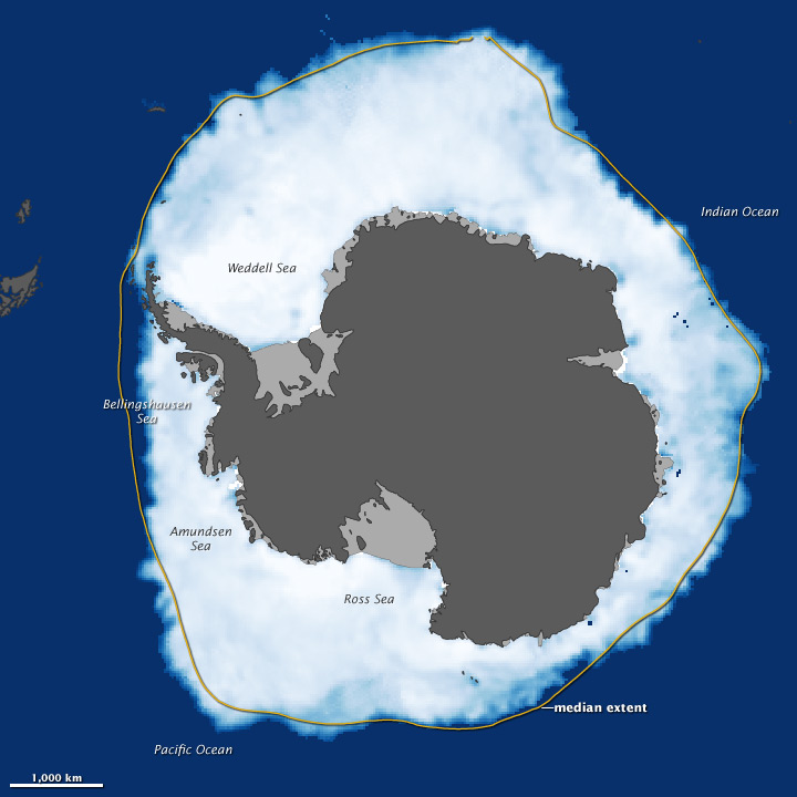
Sea Ice In Sep. 2012
The map above shows sea ice extent around Antarctica on September 26, 2012, when ice covered more of the Southern Ocean than at any other time in the satellite record. The map is based on an NSIDC analysis of data from the Special Sensor Microwave/Imagers flown in the Defense Meteorological Satellite Program. Land is dark gray, and ice shelves—which are attached to land-based glaciers but floating on the ocean—are light gray. The yellow outline shows the median sea ice extent in September from 1979 to 2000. Sea ice extent is defined as the total area in which the ice concentration is at least 15 percent.
Older Breaking News:
Greenpeace are forced to intercept a Shell ship (again)
Greenpeace Nordic activists have intercepted and boarded a Shell-contracted icebreaker, the Nordica, at open sea to continue the protest against Shell's destructive plans to start drilling in the Arctic. Just two days ago, dozens of activists occupied that same ship in Helsinki, before it left harbour!
The Nordica is heading to Alaska to join its sister ship, the Fennica, to support the Kulluk and Noble Discoverer, the two drillships that are en route to the north coast of Alaska to drill five exploratory wells for Shell in the Beaufort and Chukchi Seas.
The Nordica is heading to Alaska to join its sister ship, the Fennica, to support the Kulluk and Noble Discoverer, the two drillships that are en route to the north coast of Alaska to drill five exploratory wells for Shell in the Beaufort and Chukchi Seas.
